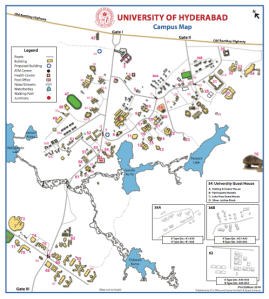
We’ve needed a manageable campus map for quite some time, what with the number of buildings, Centres, Departments and Schools increasing as they have done in the past few years. Not to mention the increasing numbers of residents of the campus, as well as of visitors…
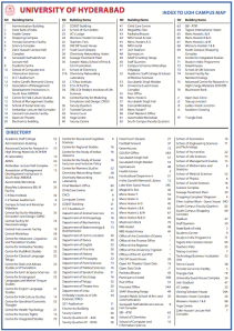
Thanks to the efforts of Prof. A C Narayana of the UCESS we now have a functional map which is well indexed, and which can be downloaded here on our Campus rEsources page.
There was always Google Earth of course, but having a map with all buildings indicated on it and numbered is an advantage. Invaluable when giving directions to those coming from outside, and often even those within the campus!
The map itself is schematic (mainly so we can fit it on an A4 sheet), and if you note omissions and major inaccuracies, or would like inclusions, please write in and let us know.


If a colour laminated sheet of it can be made and circulated that would be very helpful. Also, large versions of it can be placed at major junctions.
We are planning large versions near major junctions once all the suggestions come in.
this is amazing it helps to trace locations and can guide me t them. i will also pin favourite places on campus which i share thru bonding. i have a feeling this should also indicate uninhabited regions to conserve and protect our nature, rare species and water bodies on campus.
Coming to this blog for the first time! An honest and engaging attempt… I especially liked the header pictures. All clicked by the blogger?
The no.18 in the map is called “Central Instruments Facility” , while the actual (given/existing) name is Central Instruments Laboratory.